Determining Contour Intervals
Contour lines can be drawn for any elevation, but to simplify things, only lines for certain elevations are drawn on a topographic map. These elevations are chosen to be evenly spaced vertically. This vertical spacing is referred to as the contour interval. For example the maps on the previous page used a 10 ft contour interval. Each the contour lines was a multiple of 10 ft.( i.e. 0, 10, 20, 30). Other common intervals seen on topographic maps are 20 ft (0, 20, 40, 60, etc), 40 ft (0, 40, 80, 120, etc), 80 ft (0, 80, 160, 220, etc), and 100ft (0, 100, 200, 300, etc). The contour interval chosen for a map depends on the topography in the mapped area. In areas with high relief the contour interval is usually larger to prevent the map from having too many contour lines, which would makes the map difficult to read.
The contour interval is constant for each map. It will be noted on the margin of the map. You can also determine the contour interval by looking at how many contour lines are between labeled contours.
For the maps on this web site, however, the contour interval is not listed because we only have parts of topographic maps, not the whole map which would include the margin notes. However we usually don't need to be given the contour interval, we can calculate it from the labeled contours on the map as is done below.
The example at right is a section of a topographic
map. The brown lines are the contour lines. The thin lines are
the normal contours, the thick brown lines are the index contours.
Notice that elevations are only marked on the thick lines.
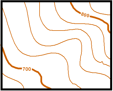
Because we only have a piece of the topographic map we can not look at the margin to find the contour interval. But since we know the elevation of the two index contours we can calculate the interval ourselves. The difference in elevation between the two index contours (800 - 700) is 100. We cross five lines as we go from the 700 line to the 800 line (note we don't include the line we start on but we do include the line we finish on). Therefore if we divide the elevation difference (100) by the number of lines (5) we will get the contour interval. In this case it is 20. We can check ourselves by counting up by 20 for each contour from the 700 line. We should reach 800 when we cross the 800 line.
Once we know how to determine the elevation of the unmarked contour lines we should be able determine or at least estimate the elevation of any point on the map.
Using the map below estimate the elevation of the points marked with letters
Point A = 700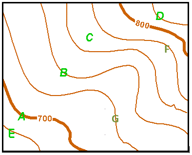
An easy one. Just follow along the index contour from point A until you find a marked elevation. On real maps this may not be this easy. you may have to follow the index contour a long distance to find a label.
Point B = 740
This contour line is not labeled. But we can see it is between the 700 and 800 contour line. From above we know the contour interval is 20 so if we count up two contour lines (40) from 700 we reach 740.
Point C ~ 770
Point c is not directly on a contour line. But by counting up from 700 we can see it lies between the 760 and 780 contour lines. Because it is in the middle of the two we can estimate its elevation as 770.
Point D = 820
Point D is outside the interval between the two measured contours. While it may seem obvious that it is 20 above the 800 contour, how do we know the slope hasn't changed and the elevation has started to back down? We can tell because if the slope stated back down we would need to repeat the 800 contour. Because the contour under point D is not an index contour it can not be the 800 contour, so it must be 820.