Topographic Maps
Topographic maps are important tools for studying the earth's surface, not only for geologists, but also for engineers, foresters, land use planners, hikers, ... virtually anyone who travels outdoors. Topographic maps summarize the three dimensional topography of the earth's surface on two dimensional pieces of paper (or computer screens).
These web pages are designed to be an introduction to topographic maps for geology students. Additional information on topographic maps can be found at the USGS web site and the Topozone web site.
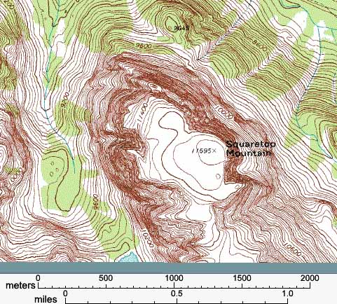
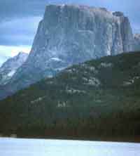
Lets use the area around Squaretop Mountain (shown below) to illustrates the power of topographic maps. Squaretop Mountain is located in the Wind River Mountains of Wyoming. The photo of Squaretop Mountain (taken looking south) shows some of the important topographic features of the mountain. From the photo we can see that the top of Squaretop Mountain is capped by a relatively wide flat area (which gives the mountain its name). This area is not horizontal, instead it slopes down to the west (to the right in the photo). Surrounding this flat area are extremely steep slopes (cliffs). At the base of these cliffs the slope decreases (though it is still very steep).
|
|
|
A skilled reader (well not really even that skilled) of topographic maps could make the same observation from the map without even seeing the photo. The slightly sloping top, the cliffs, and the lesser slopes on this mountain are all evident on the topographic map. By the time you have gone through these web pages you should be able to read the topographic well enough to recognize topographic features of Squaretop Mountain.
But if we can determine the same information from the photograph why do we need to worry about learning to read topographic maps? Well, first we may not always have a photograph, or we may be looking at areas where the topography will not show up well in a photograph. Topographic maps are much more widely available. Second the topographic map provides more information. From our map of Squaretop Mountain we can measure the size of the top part of the mountain (just under 1 km x 0.5 km). We can determine the elevation of the submit of Squaretop Mountain (11695 ft) and estimate its relief (height above the valley floor, ~3500 ft). We can also study the topography from parts of the mountain that can't be seen in the photograph. For example from the map we can see that the slopes that are not as steep on the south side of the mountain (the side that is behind the mountain in the photograph), information that might prove very useful if we were trying to climb a mountain. None of this information is available from the photograph. Instead it is the topographic map that provides us with the detailed information we often seek as geologist.
|
|
Back to previous page | Back to home page |
Next page |
|