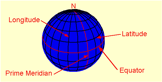
Latitude and Longitude
Longitude works the same way. It is angular distance measured east and west of the Prime Meridian (which has been arbitrarily set at Greenwich, England). The prime meridian is 0 degrees longitude. As you go east from the prime meridian, the longitude increases to 180 degrees. As you go west from the prime meridian longitude increases to 180 degrees. The 180 degree meridian is also known as the international date line. In the eastern hemisphere the longitude is given in degrees east and in the western hemisphere it is given in degrees west.
How Accurate Can Latitude and Longitude Get?
At the equator, one degree of latitude or longitude represents approximately 70 miles. At higher latitudes the distance of one degree of longitude decreases. Latitude stays the same because they are always equally spaced apart. If you look on a globe you will see this to be the case. On the other hand, if you look on a globe you will notice that the lines of longitude get closer together as they approach the north and south poles.
The basic unit of latitude and longitude is the degree (°), but degrees are a large unit so we often have to deal with subdivisions of a degree. Sometimes we just use a decimal point, such as 35.789°N . This format is referred to as decimal degrees. Decimal degrees are often found as an option on Global Position Systems (GPS) or with online topographic maps, but decimal degrees are not used on printed maps. On these topographic maps the latitude and longitude units are expressed in degrees, minutes, and seconds. Each degree is subdivided into 60 minutes('). Each minute is divided into 60 seconds(''). Note the similarity to units of time which makes these relationships easy to remember. If we are interested in a general location we may just use degrees (one degree is equal to approximately 70 miles). For more precision we specify minutes (about 1.2 miles), or even seconds (0.02 miles). Note that we always need to specify the larger unit. You can't specify your latitude or longitude with just minutes or seconds. A coordinate such as 25' is meaningless unless the degrees are also given, such as 45° 25'.
Reading Latitude and Longitude on a map
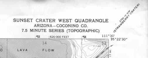
If you look at the picture above you will notice the latitude and longitude in the upper right hand corner of the map. You would read it as 35 degrees 22 minutes 30 seconds north latitude and 111 degrees 30 minutes west longitude.
Below the title you will notice the words 7.5 minute map. This means that the map covers an area of 7.5 minutes of latitude and longitude.
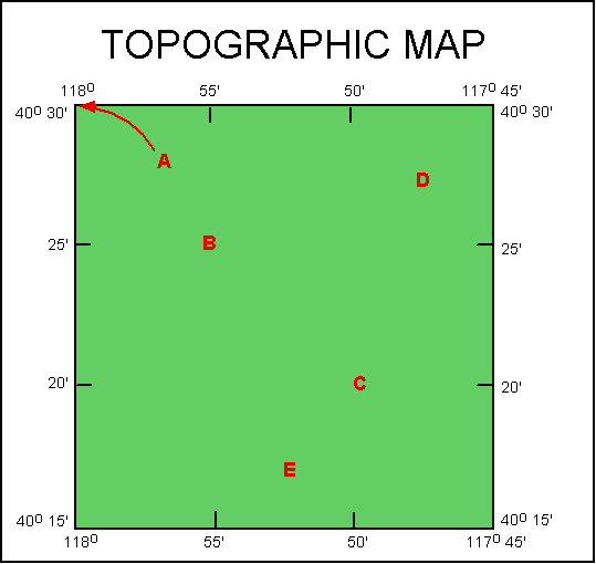 First lets determine what the numbers on the map
mean. The numbers on the left and right side of the map are
latitude. (As always we are assuming that north is to the top of the
screen). The numbers across the top and bottom of the map are
longitude.
First lets determine what the numbers on the map
mean. The numbers on the left and right side of the map are
latitude. (As always we are assuming that north is to the top of the
screen). The numbers across the top and bottom of the map are
longitude.
Lets determine what type of quadrangle this map represents. Longitude on the left of the map is 118°, longitude on the right side of the map is 117° 45'. The difference between these two is 15'. Latitude of the top of the map is 40° 30' and the latitude of the bottom of the map is 40° 15'. The difference between these two is also 15'. This map, which covers an area that is 15' x 15' would be referred to as a 15 minute map.
Notice that latitude and longitude is only fully written in the corners of the map. Along the edges of the map only the minutes are written. The map reader must realize that 20' latitude on this map is actually 40° 20', because 20' lies in between 40° 15' and 40° 30'.
We can also use latitude and longitude to give the location of points on a map. Estimate the location of each of the red letters on the map in terms of latitude and longitude. The answers are below.
| POINT | Latitude | Longitude | Explanation |
| A | 40° 30' N | 118° W |
Point A is in the upper left corner of map so its coordinates are the printed coordinates of this corner. The one thing that needs to be added are the direction notations of each coordinate. They are not printed on the map because it is assumed you can tell what hemisphere you are in. When you are asked for latitude and longitude you must add these letters. It is easy to tell where you are by which direction the numbers for latitude and longitude increase. Latitude increase going north on this map so we are in the northern hemisphere. Longitude increases going to the west, so this map is located west of the Prime Meridian. |
| B | 40° 25' N | 117° 55' W | To determine the location of point B we need to read across to the side of the map (to determine latitude) and up to the top of the map to determine longitude. Point B lines up with labeled tick marks labeled 25' and 55', but we know these numbers are incomplete. looking at the corner of the map we see that the latitude is 40° 25' N (north because of same argument for point A) and the longitude is 117° 55' W. |
| C | ??? | ??? |
Follow the same procedure as point B above.
|
| D | 40° 27' 30" N | 117° 47' 30" W | Point D does not line up directly with tick marks. Instead we need to estimate its location. Point D looks like it is half way between the 25' and 30' marks for latitude and half way between the 45' and 50' marks for longitude. Half way for each of these is 27'30" and 47'30". Remember one half a minute is 30 seconds. Adding the remaining parts of the coordinates as we did above give us the answer. |
| E | 40° 16' N | 117° 52' 30" W | Solved the same as point D above. The only difference is in estimating the minutes for latitude. Point E seems to closer to 15' that to 30' so I have estimated it as 16'. This is only an estimate so the answer can vary, but it should be greater than 15' and less than 17' 30" |