Gradient (Slope)
Topographic maps are not just used for determining elevation, they can also be used to help visualize topography. The key is to study the pattern of the contour lines, not just the elevation they represent. One of the most basic topographic observation that can be made is the gradient (or slope) of the ground surface. High (or steep) gradients occur in areas where there is a large change in elevation over a short distance. Low (or gentle) gradients occur where there is little change in elevation over the same distance. Gradients are obviously relative. What would be considered steep in some areas (like Ohio) might be considered gentle in another (like Montana). However we can still compare gradients between different parts of a map.
On a topographic map the amount of elevation change is related to the number of contour lines. Using the same contour interval, the more contour lines over the same distance indicates a steeper slope. As a result, areas of a map where the contour lines are close together indicate steeper slopes. Areas with widely spaced contour lines are gentle slopes. The map below shows examples of areas with steep and gentle gradient. Note the difference in contour line spacing between the two areas.
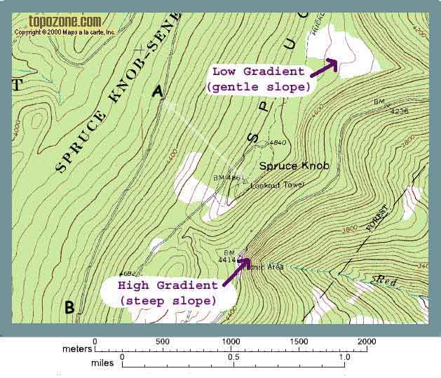
Compare the slope of the west side of Spruce Knob with the slope of the east side. Which side is steeper?
It is possible to calculate the gradient right off the map. Gradient is simply the rise over the run. Which is to say the elevation change divided by the horizontal distance. Let's say you parked your car on the road by the end of the white arrow (point "A") on the Spruce Knob map. Further let's say you want to hike from there straight up to the top of the Knob (following the white arrow). You need to know two things to determine the gradient: 1) the horizontal distance and 2) the elevation change.
- The elevation change (or "rise") is simply the difference between the elevation of your car at point "A" (which we can see as 4200' because it sits right on a contour line) and the elevation at the top of Spruce Knob (which is labeled as 4861'). So the elevation change is 4861 - 4200 = 661 feet.
- Because this map is on a computer screen, it is a little difficult to measure horizontal distance accurately. Let's assume the distance is 2000 feet. So 2000 feet is your horizontal distance (sometimes called the "run").
So the gradient is (rise/run) 661'/2000' = 0.33 Which is commonly stated as 33%
Now it's your turn. Figure out the gradient of the ROAD from point "A" to point "B". Once again because it may be a little tough to measure distance on the computer screen (and I want everyone to come up with the EXACT same number) let's assume the distance is exactly one mile.
Before you begin I need to tell you one last thing. When calculating gradient, the units for rise and the units for run MUST BE THE SAME. So if you use feet for the rise, you must also use feet for the run, which means you will need to convert 1 mile into feet (1 mile = 5280 ft).
So, what is the gradient of the road?