Magnetic Declination
Another feature found in the legend of topographic maps is the magnetic declination. Magnetic declination is the difference between true north (the axis around which the earth rotates) and magnetic north (the direction the needle of a compass will point)
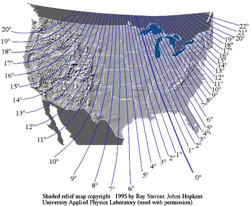
Magnetic north is determined by the earth’s magnetic field and is not the same as true (or geographic) north. The location of the magnetic north pole changes slowly over time, but it is currently northwest of Hudson’s Bay in northern Canada (approximately 450 mi from the true north pole). Maps are based on the geographic north pole because it does not change over time, so north is always at the top of a quadrangle map. However, if you were walk a straight line following the direction your compass needle indicates as north, you would find that you didn’t go from south to north on the map.
How far your path varied from true north depends on where you started from; the angle between a straight north-south line and the line you walked is the magnetic declination in the area you were walking.
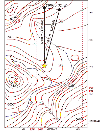
In the example, if you walked 1.25 miles toward magnetic north (i.e. you followed your compass without adjusting for magnetic declination) you would end up 1/3 of a mile away from where you would be if you walked 1.25 miles toward true north.
Fortunately, magnetic declination has been measured throughout the U.S. and can be corrected for on your compass (see below).
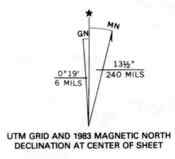
At the lower left hand corner of topographical maps there is a symbol called the magnetic declination. The symbol is used in conjunction with a compass for navigational purposes. The center line with the star above represents the direction of true geographic north. The line coming of to the right represents the direction of magnetic north, When using a compass, the needle always points to magnetic north. The symbol tells you that for the area the map covers, the magnetic compass needle will always point 13.5 degrees to the east of true geographic north. To the left of the true north line is the grid north line. This tells you how much the UTM grid and zone lines are offset from true north.