UTM Coordinates
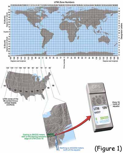
 Every spot within a zone can be defined by a
coordinate system that uses meters. Your vertical position is defined in terms
of meters north and your horizontal position is given as meters east. They
are sometimes referred to as your northing and easting. In the following
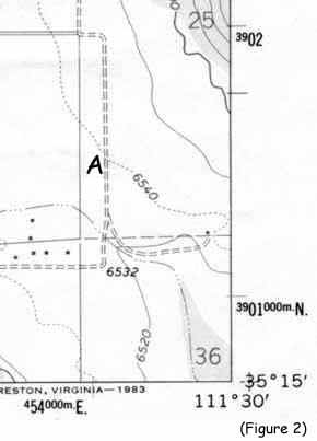
picture you can see the northing and easting coordinates on the boarder of
the topo map. They are the small bold black numbers. Along the edge of the
map the first UTM shown is 3901000 meters north. On a regular topo map the
dash above that number would be blue. As you go up the right hand side of
the map, the next UTM is 3902000 meters north. As you go up the right hand
side of the map every time you pass a the small blue dash you have gone up
1000 meters (one meter = 3.281 feet). The same applies with the UTM's
across the bottom of the map. As you move to the right the number gets
larger and there is 1000 meters between each tick mark.
Every spot within a zone can be defined by a
coordinate system that uses meters. Your vertical position is defined in terms
of meters north and your horizontal position is given as meters east. They
are sometimes referred to as your northing and easting. In the following
picture you can see the northing and easting coordinates on the boarder of
the topo map. They are the small bold black numbers. Along the edge of the
map the first UTM shown is 3901000 meters north. On a regular topo map the
dash above that number would be blue. As you go up the right hand side of
the map, the next UTM is 3902000 meters north. As you go up the right hand
side of the map every time you pass a the small blue dash you have gone up
1000 meters (one meter = 3.281 feet). The same applies with the UTM's
across the bottom of the map. As you move to the right the number gets
larger and there is 1000 meters between each tick mark.
Look at point "A" on the map. It is about half way between the two labeled UTM tic marks (3,902,000 and 3,901,000), so it's northing is about 3,901,500. Point "A" is directly above the UTM tic mark 454,000, so it's easting is 454,000. This map is located in UTM zone 12 so the correct location for point "A" using UTM coordinates is:
12N 454,000 3,901,500